


- MV Alta, a merchant ship that was reportedly lost has washed ashore after a storm.
- It had passed unseen as a drifting ghost ship before appearing on the Irish coast.
- It was abandoned in 2018 south of Bermuda after a mechanical failure.
- The 77-meter cargo vessel’s odyssey came to an end during Storm Dennis.
- The towed ship was hijacked, with its fate unclear until August 2019.
- It was briefly sighted by the HMS Protector in the mid-Atlantic, apparently unmanned.
According to an article published in the Hackaday and the Guardian, Jenny List and Rory Carroll have reported that a merchant ship that was reportedly lost has washed on the coast of Country Cork after a storm.
How the ship got lost at sea?
The MV Alta is a nearly 2300t and 77m (just over 253 ft) freighter that had been abandoned in 2018 south of Bermuda after a mechanical failure had rendered it incapable of navigation. Its crew had been rescued by the US Coast Guard, and since then — apart from a brief sighting in mid-Atlantic by a Royal Navy polar research vessel — it had passed unseen as a drifting ghost ship before appearing on the Irish coast.
In a very literal sense it had dropped off the radar, but the question for us is how? With the huge array of technological advances in both navigation aids and global sensing available at the end of the 21st century’s second decade, should that even be possible? It’s worth taking a while as land-lubbers to look at how ships are tracked, to try to make sense of the seeming invisibility of something that is after all pretty large and difficult to hide.
Ghost-ship traversed the Atlantic

MV Alta, a ghost ship that traversed the Atlantic for more than a year without crew or passengers, berthed at last. The 77-meter cargo vessel’s odyssey came to an end during Storm Dennis last Sunday when it ran aground near Ballycotton, a fishing village in County Cork, Ireland, overlooking the Celtic Sea.
Photographers gained access to the site on Wednesday, giving the first proper close-up look at a ship that has caught the public’s imagination. A local coastguard official called the landing a one in a million chance.
Built in 1976, the Alta was flagged in Tanzania, changed owner in 2017 and was sailing from Greece to Haiti in September 2018 when it became disabled about 1,380 miles (2,220km) south-east of Bermuda.
Unable to make repairs, the 10-strong crew was rescued by the US coastguard cutter Confidence, which brought the crew members to Puerto Rico.
The ship was reportedly towed to Guyana and then hijacked, with its subsequent fate unclear until August 2019 when a Royal Navy ice patrol ship, HMS Protector, encountered it in the mid-Atlantic, apparently unmanned.
Ship inspected

Marine contractors working for Cork county council boarded the freighter on Tuesday and carried out a preliminary examination of the ship and any pollution risk from potential fuel spillage.
Not all fuel tanks were accessible but initial indications suggested they held only a small amount of diesel fuel.
There is no cargo on board but some sealed containers with oil could pose a pollution risk in the event of spillage, the council said in a statement.
The contractor was due to start pumping water from the vessel on Wednesday, and there are plans to remove the containers.
One Of These Maps Is Not Like The Other

Perhaps in understanding this, it’s best to start by looking at the scale of the distances involved. We are used to viewing the world in terms of the map on the wall in your primary school. Known as the Mercator projection, a spherical globe has been distorted into a cylinder which can then be unwrapped as a rectangular piece of paper. On this side of the Atlantic, they have Europe and Africa roughly in the center, with the International Date Line skirting New Zealand on their right, and the Pacific ocean and Alaska on their left. Doing this makes it easy for us to create a mental picture of where places are in the world, but creates a significant distortion in our perception of distance.
Greenland, for example, is many times smaller than its depiction in a Mercator projection, and the distance across the far north Atlantic from Greenland to Norway appears as the same as that from for example New York to Morocco. In reality, the former is in the region of 1000 miles while the latter is over 3500 miles. As a comparison, the road distance between New York and San Francisco is about 2900 miles.
The Atlantic, It’s Bigger Than You Imagine
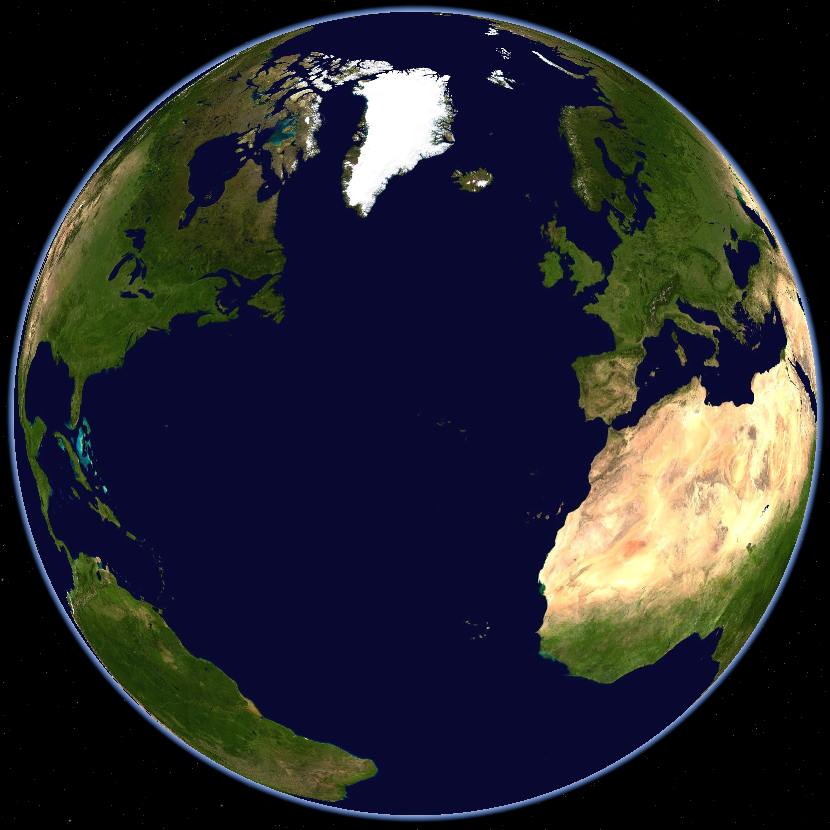
Viewing the Atlantic on a spherical projection then shows the true size of the ocean, as the American mid-west is on one horizon and the Middle East on the other, with the sea occupying most of the visible surface. If by some engineering magic there were a road bridge across it I would take about a week to drive the distance in my little hatchback, but in fact, aside from a few islands such as Bermuda or the Azores, there is nothing. A look at any of the online ship tracking sites that map reports from AIS transponders appear to show it as crowded with shipping, but even then that is an illusion created by the size of the icons on a web page. In fact on those maps each ship is a fraction of a pixel in size on the in-browser map, their optical horizon in the region of 5 km is the same, as is their roughly 20 nautical mile X-band radar view.
In that light, it’s easy to believe that the captain of a ship such as the Alta could plot a course that would keep it away from other craft and effectively disappear from view in a space that vast. It’s not impossible that without a captain and with its AIS transponder out of action it could also drift unseen through the same space.
You Won’t Find It Unless You Go Looking For It
![One of the US Navy's venerable Lockheed P-3 maritime patrol aircraft. US Navy [Public domain]](https://hackaday.com/wp-content/uploads/2020/02/1024px-Orion.usnavy.750pix.jpg)
So aside from that passing visual encounter with the Royal Naval vessel, it achieved the feat of crossing the Atlantic unseen. But surely we live in the 21st century, don’t our governments ceaselessly monitor the waves for would-be enemies? The answer to that is, we hope, yes, but even then it’s fair to say that seeking out drifting Panamanian-flagged merchant ships is unlikely to be a priority.
They may have radar-equipped maritime patrol aircraft in the sky, undersea hydrophones, and satellite monitoring overhead, but all of those things require naval intelligence to direct them towards a vessel of interest. If intelligence indicates a potentially hostile ship has left port, then a formidable array of machinery and technology will shadow its every move. But the Alta, floating rudderless with no one aboard, hardly fits the bill as a threat to global security. Indeed it could have evaded some of those systems anyway, as, without the engine or wake of a ship under power to detect, they simply wouldn’t have found it.
We hope the Alta will not cause a headache to the Irish authorities and that perhaps a few extra tourists come and spend their Euros in the area when they come to see it, but if its fate tells us anything it is this: We sometimes like to believe that we are the masters of our world, when in fact over so much of its surface we are still as at the whim of nature as our ancestors were centuries ago when they crossed oceans in tiny wooden craft.
Did you subscribe to our daily newsletter?
It’s Free! Click here to Subscribe!
Source: Hackaday & TheGuardian


