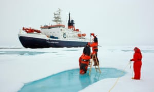
In September, the giant German polar research vessel Polarstern will set off from Tromsø in Norway on a remarkable voyage. It will sail across the Arctic Ocean and after a few weeks reach a point off the Siberian coast, around 85 deg N 120 deg E, where it will attach itself to the biggest, strongest-looking ice floe its crew can find. And then, for the next year, the Polarstern will remain moored to this giant slab of frozen water as it slides, with other polar pack ice, round the Arctic Ocean, reports the Guardian.
What is it studying?
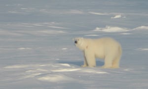
For a year, teams of researchers from the ship will study conditions on the ice floe – which will be at least 2 sq km in area to satisfy researchers’ requirements. There they will set up instruments to study the atmosphere above them, the seabed below, the chemistry of the water around them, the Arctic Ocean’s sealife, and the behaviour of wildlife on the surface, including the occasional visiting polar bear.
Mosaic Observatory Studying the Arctic
This is Mosaic – the Multidisciplinary drifting Observatory for the Study of Arctic Climate, the biggest international expedition ever launched in the Arctic. Its aim is to transform our knowledge of the north polar region, a place more affected by climate change than any other sector of our planet and which is expected to play a crucial role in determining how global warming impacts on the rest of the Earth.
“The Arctic is closely linked to weather in our latitudes,” says expedition leader Markus Rex, of the Alfred Wegener Institut in Germany. “We can already see climate changes in the Arctic that are shaping our weather and climate. However, we won’t succeed in accurately forecasting climate developments if we don’t have reliable prognoses for the Arctic.”
How will it be done?
- Backed by an international consortium led by the institute, Mosaic will cost more than £100m to complete.
- At any one time, around 50 scientists will be working on its prime vessel or on the ice to which it is moored.
- Regular visits by icebreakers from China, Russia and Sweden will keep the Polarstern supplied and recrewed so that by late 2020, when the project ends, more than 300 researchers from at least 17 nations will have taken turns to work there.

Drifting A Vessel in Ice?
The idea of simply letting a research vessel drift across the polar cap trapped in ice is not new. The Fram expedition, led by the great Norwegian explorer Fridtjof Nansen, lasted from 1893 to 1896, as his boat, gripped in sea ice, drifted across the Arctic Ocean and demonstrated the feasibility of such arduous undertakings. By modern standards, the scientific measurements taken by its crew were limited, however.
Mosaic, by contrast, will return reams of data, most of it aimed at helping researchers forecast the likely fate of our planet as it heats up as more and more greenhouse gases are pumped into the atmosphere. “The Arctic is crucial to understanding how climate change will affect the rest of the planet,” says Jeremy Wilkinson, a British physicist working on Mosaic.
How will it help in measuring climate change?
This point is backed by Markus Frey, a polar explorer based at the British Antarctic Survey. (Britain’s research in the north pole is managed by the Arctic Office at the British Antarctic Survey.)
“In the Arctic Ocean – because there is no land on which to build research bases – there is a lack of data about conditions there apart from the information we get from satellites and a few other sources,” tells the Observer. “We need to calibrate the data we get from space with events and the observations we make on the ground, or to be more precise at sea level, in order to get a more accurate picture of what is going on there.”
Consider the issue of sea-ice thickness in the Arctic. For more than 40 years satellites have swept over the north pole and charted dramatic declines in sea-ice cover as global warming has inexorably strengthened its grip on Earth. According to Nasa, the area covered by Arctic sea ice in summer has shrunk by about 40% since the 1980s. That represents the loss of several million square kilometres of sea ice – and as it disappears, more solar radiation will reach the dark, heat-absorbing waters of Arctic Ocean that once lurked underneath. As a result, temperatures will rise even further, researchers warn.

Verifying 2 dimensional Satellite Photographs
Photographs from most polar satellites only give a two-dimensional picture of the sea ice, however. They do not reveal the extent to which it may be thinning or thickening. In some places, it may be only wafer-thin and set to disappear with dramatic rapidity.
“Recent satellites have been fitted with radar that can measure ice thickness from space,” says Wilkinson. “They have been carefully tuned so they are not confused about levels of snow that have fallen on top of the surface of the ice and apparently altered its thickness.”
The European Space Agency’s probe CryoSat-2 and the French-Indian satellite AltiKa are examples of space missions designed to measure Arctic sea-ice thickness using radar. However, scientists have found these devices do not always pinpoint the surface of the sea ice properly. They still get confused by light snow lying on top of ice. “And that means we are getting errors in our measurements of ice thickness,” adds Wilkinson.
How will it help in measuring ice thickness?
Mosaic should provide a solution. Radar instruments identical to those fitted to CryoSat and AltiKa will be taken on the Polarstern. “We will mount these on a sled and scientists will drag them across the sea ice,” says Wilkinson. “It will be like bringing the satellites down to the surface of the sea ice. Using them, we will then be able to compare the readings we get on the sea-ice surface with those that we got from space. We should be able to recalibrate the satellites’ instruments to get very much improved, more accurate readings of Arctic sea-ice thickness when measured from Earth orbit.”
In fact, he adds, dozens of related programmes will be carried out on Mosaic. “Other researchers are doing work on snow chemistry and snow properties and we can get our radar measurements married to their snow measurements to get this holistic understanding of how snow evolves in the Arctic.”

Scientists still do not know exactly how this process works, however, and a key feature of Frey’s research will be to unravel the detailed way salt is spread round the Arctic atmosphere. “We need to understand how salt affects the formation of clouds. If you don’t understand that process, you will not get your climate forecasts right. It is a missing link in our meteorological knowledge, so this research is crucial. After all, clouds cut out sunlight and if they do not form for some reason, the region will heat up even more than is currently predicted.”
Risks of this project
It is all intriguing work, though carrying out these projects is not without risk. For a start, polar bears pose a real danger to researchers who will have to be protected by armed guards when working on the ice floe. “The guards will have night-vision goggles and rifles fitted with infrared scopes,” adds Frey. “There will be a 700-metre perimeter placed around project sites that will be protected with tripwires. There will also be someone on the bridge looking out at what is happening on the ice floe. However that will still be a challenge at night, especially when visibility is bad during storms. We will have to take constant care. Bears are a serious issue.”
Nor will wildlife be the only risk. Extreme Arctic weather also poses danger as Frey found out during his last expedition. The N-ICE2015 project, led by the Norwegian Polar Institute, was a forerunner of Mosaic and involved the research vessel Lance getting frozen into the Arctic pack ice in January 2015 to study sea ice for several months. “It was a mini-Mosaic,” says Frey. “Just half a year in a much smaller boat.”
A lot of lessons were learned nevertheless. “Four weeks into the expedition, a huge storm shattered the ice floe into pieces,” he says. “Our equipment was thrown everywhere and some became frozen into the ice. It was a horrible mess. People were up to their waists in slushy, ice-cold water and after a while we had to abandon equipment as well. We had to reset our position and start all over again.”
How well prepared is Mosaic?
This time, Mosaic’s explorers have got themselves a bigger boat and will have a larger ice floe, so they are hoping they will be no repeat of the hardships their predecessors had to endure four years ago.
“This is an extremely important project because it is clear that what happens in the Arctic does not stay there,” says Wilkinson. “The weather there affects the rest of the planet. It touches us all. Just consider the issue of ice. It reflects about 80% of the sunlight that pours down on it. Remove that ice, as we are doing now, and sunlight will shine straight on to the dark ocean. Its dark waters will absorb up to 80% of the radiation that hits it. Further heating is inevitable”.
“In other words, ice is essential. It controls our weather patterns. But it is changing in nature and amount in the Arctic. And that is one of the driving forces of the Polarstern. It is going to help us re-evaluate our knowledge of the new Arctic that we are creating.”
Did you subscribe to our daily newsletter?
It’s Free! Click here to Subscribe!
Source: The Guardian


